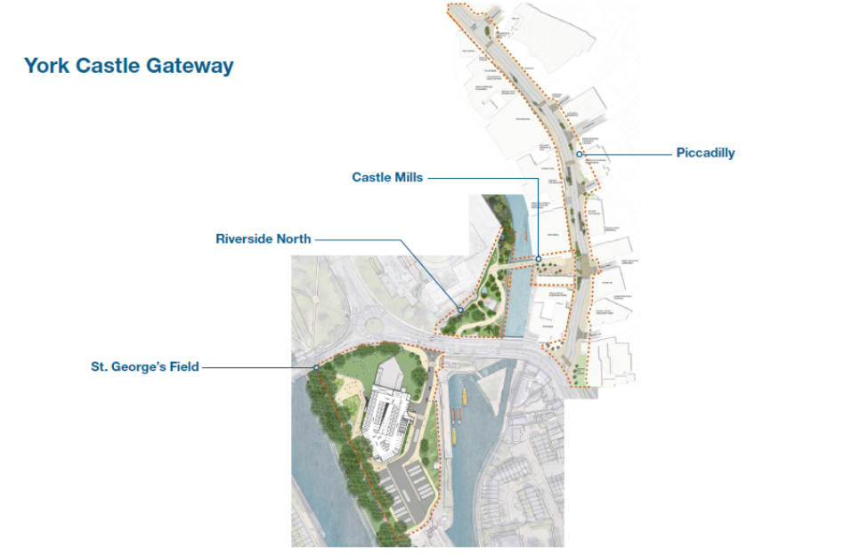
On 9th May we ran an event to explore in detail the walking and cycling routes through St George’s Field, over the Fishergate Gyratory, over the new bridge and into and along Piccadilly.
In the session we worked through the three main sections being designed at the moment: St George’s Field, then the new Foss bridge and then Piccadilly. For each section, Andy Kerr, Project lead for Castle Gateway and Stephen Marshall from BDP (the Castle Gateway architects and planners) introduced the current thinking and posed specific questions for discussion.
Shared Space
One issue that ran through out the workshop was that of ‘shared space’. It was noted that there are two types of shared space. Between cyclists and pedestrians and between cyclists and cars. As one person put it, ‘The former can be a bit awkward, but the latter can lead to death and serious injury’.
For the St George’s Field and the new Bridge, the issue was sharing space between cyclists and pedestrians. Andy Kerr noted that the direction of travel was towards shared space (e.g. recent changes to New Walk, the Millennium Bridge and Scarborough Bridge). Andy asked, is this the right direction of travel?
For many it was – arguments in favour of pedestrian and cyclists sharing space included:
- ‘There are responsible and irresponsible cyclists – but it is a cultural thing, we can create the right expectations and behaviour’
- ‘New Walk works for 9 months of the year – but it is the tourists which are the issue’
- ‘Segregated cycle lanes can create conditions where some cyclists just bomb down them’.
- There needs to be consistency – the worst case scenario is where you move from shared to segregated.
It was noted that not everyone felt the same way:
- Feedback from York Blind and Partially Sight Society has pointed towards segregation being positive. Could tactile and colour surfaces be used?
- Also for disabled cyclists who find stopping and starting and dismounting difficult, shared space poses problems.
Overall, it was felt that we needed a city-wide strategy. But could we make Castle Gateway an exemplar for the city – setting good guidelines and then rolling the approach out in to the rest of the city?
Questions:
The big question here is how to resolve the issue of shared space.
- Is there a principle here in favour of segregated cycle lanes where there is room and shared space where there isn’t?
- Or is shared space the best way forward everywhere but with better signage and materials to make it clear to people?
- How can design be used to encourage pedestrians and cyclists towards different areas within the space (as with the bridge design, see below).
- Can we learn from the various approaches taken in different parts of the city to resolve this?
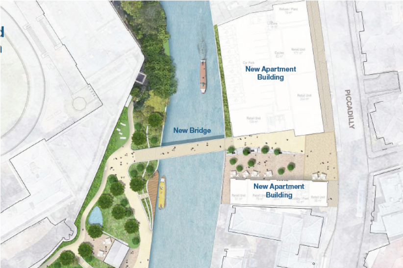
St George’s Field
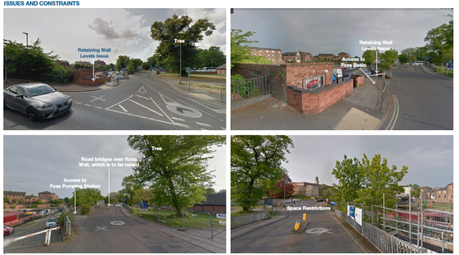
In terms of St George’s Field, Steve and Andy introduced how thinking had moved on from the last public discussions in March (read about this here). The big issue is the space constraints at the junction with the gyratory.
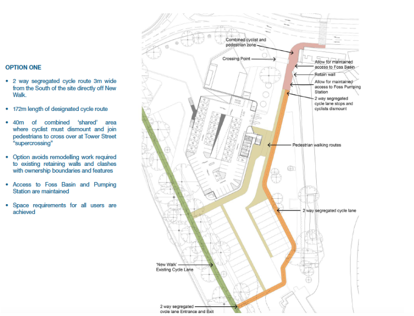
Two options were shared.
Option 1
Option 2
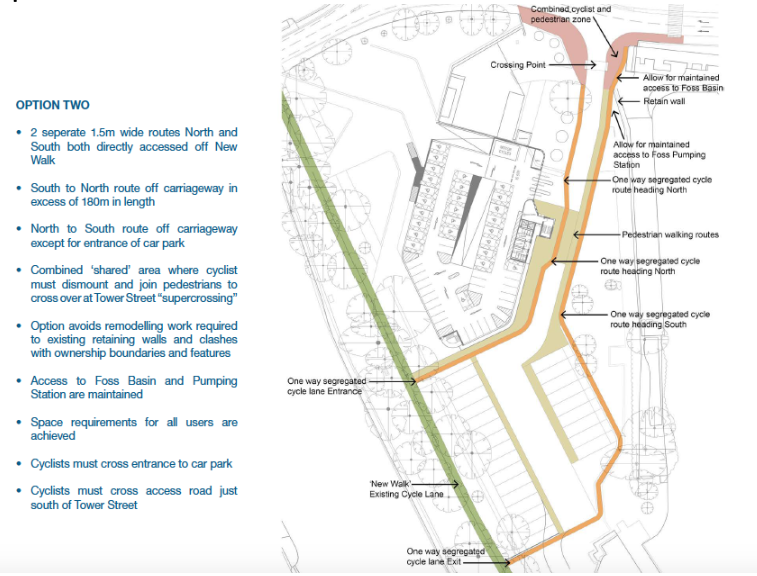
Key points from the discussion:
- Option 1 was preferred but more was wanted.
- There was a strong rejection of the idea that cyclists should dismount near the junction.
- The supercorssing providing for crossing all four lanes at once (rather than two then two) was strongly endorsed.
- It was suggested that there was a need for hedges or barriers to stop coach parties coming straight on to the new cycleway. Could there be education to change culture of the coach parties so they understand about shared space?
Next steps:
It was recognised by all that the current plans are still not ideal and further work is needed in terms of whether/how greater space could be created at the pinch point near the junction. This includes discussions with City Cruises who currently have the lease on the building at the corner with the access route to St George’s Field meets the Fishergate Gyratory.
- It was logged again – as it had been at a previous event – that Blue Bridge is an issue in this plan as it is not an accessible bridge and it is tricky to use for a wide range of types of cyclists.
The new Foss bridge
The My Castle Gateway Open Brief for the bridge
The bridge was welcomed. In terms of the ‘shared space’ debate, using the design of the bridge to encourage pedestrians and cyclists to different sides of the bridge was seen as a good idea. ‘It is good to create self-organisation and spontaneous learning – you don’t want to create things that create spontaneous learning in the wrong place’.
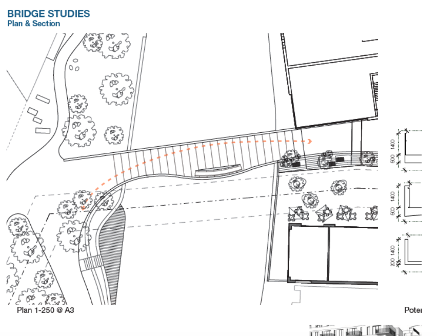
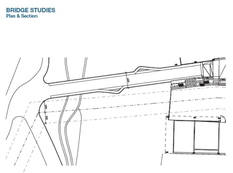
In terms of managing shared space:
- Using the bowing to the south was seen as better than the lay-bys on either side. We discussed the views and the views south seem more likely to be attractive.
- There is a natural crossing point (where cyclists will cross pedestrians path) – on the west side of the bridge that needs to be thought through.
Piccadilly
The My Castle Gateway Open Brief for the area.
The big idea for Piccadilly is to create a city living neighbourhood; a place which is a destination and not only a route through. The new plans explore how to distribute the space and how cycling would be managed.
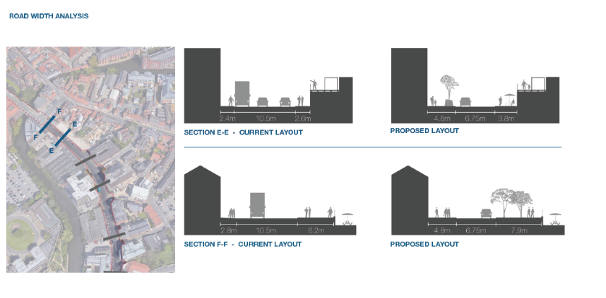
A range of options were considered and modelled to meet both the aspirations of the brief, the practical requirements of a bus route and the need to service commercial buildings such as shops and hotels that require regular deliveries.
One key issue relates to the amount of space available at the top end of the street (where Spark and Banana Warehouse are). Due to other proposed uses for the space, including large pavements for planting, for street cafes and benches and loading bays for the new hotels, an option explored was to have cyclists share the road in primary position. (Although the current carriageway is 10.5m, on-street parking effectively reduces the existing carriageway shared by vehicles and cyclists to 6.75m).
Cycle Lane in the Road – Primary Position
Having considered all of those constraints, and taking into account Sustrans best practice guidance and the City of York Council transport hierarchy the preferred option, put forward by the transport designers and technical officers, was as follows:
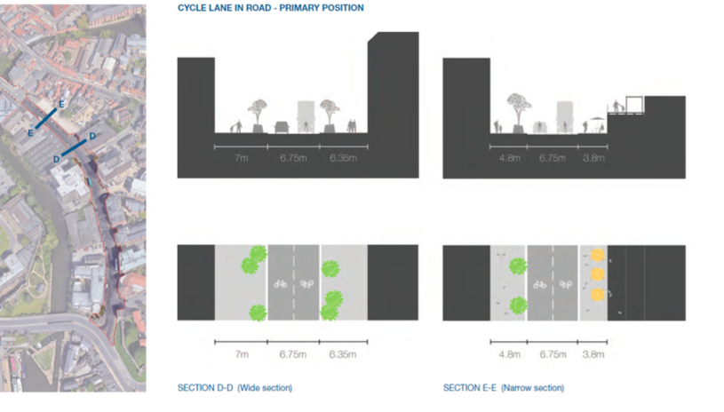
The rationale for this is that at the narrowest section of the street pedestrians, planting and off road loading bays can be accommodated as well as the minimum required road width for buses to safely pass of 6.7m. The road would become parking restricted meaning whilst the carriageway would be reduced there would be no stopping or obstructions other than bus stops. The transport designers and technical officers felt that a safe cycling environment would be created by the combination of the reduced highway width, low traffic volume and much lowered traffic speeds through traffic calming tables along with restricting parking so that there are no vehicle obstructions for cyclists to navigate in the carriageway other than bus stops.
Segregated cycling lane options
The following sets out the different options the transport designers and technical officers explored to inform their decison about why they believe the options for segregated cycle lanes are problematic in this instance:
Cycle Lane in Road – secondary positon
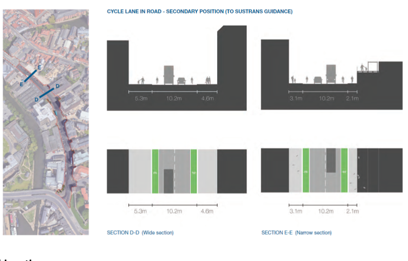
This option:
- Does not create the minimum 6.7m bus passing width of carriageway.
- Would not allow for the loading bay for the new hotels and existing Tesco deliveries at the narrowest section of Piccadilly to be taken off the highway. This would mean servicing vehicle would cause obstructions to buses and sever the cycle lane.
- Would not create wide enough pavements to accommodate planting, seating and cycle parking.
Cycle lane in the road – secondary positon with greater space for bus passing
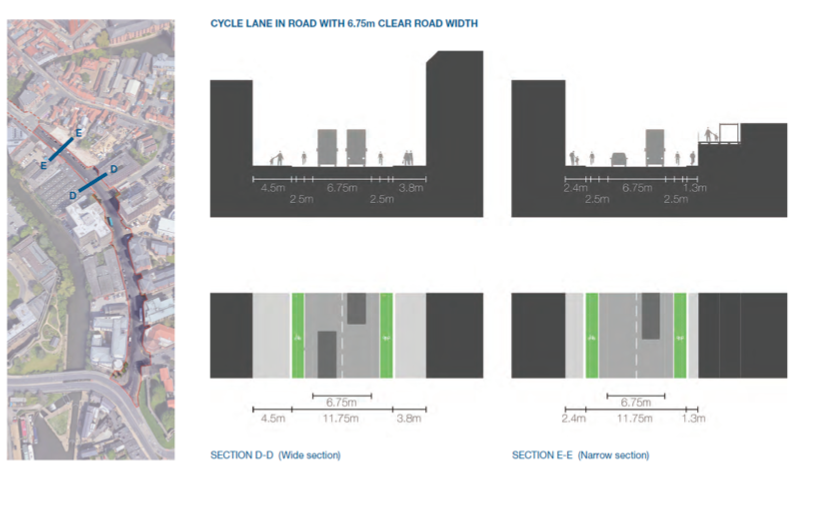
This option allows for the 6.75m required for buses to safely pass without encroaching on the cycle lane, but as a consequence makes the road wider still and leads to even smaller footpaths, reduced to only 1.3m at the narrowest point, exacerbating the issues with the previous option.
Segregated two way cycling lane
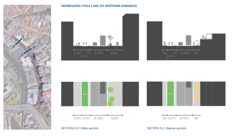
A two-way segregated cycle lane was also considered but this again would not:
- Allow the space for loading bays to be taken off the carriageway and at the narrow section of Piccadilly there would be no space for planting, seating or activity with a very narrow pavement.
- As loading bays and servicing would need to be in the road it would also pose a risk to cyclists of delivery drivers and bus passengers crossing over the cycle lane.
Key points from the discussion:
There was a very strong feeling in the room that from a cyclist perspective that the prefered option (cyclists in primary position) was not acceptable. One person said: ‘This has made it worse than it is at the moment – it works ok at the moment’. Others said that if there were no segregated cycling lane then this would mean that they would not cycle this way. It was argued that the big opportunity of this scheme was to create a continuous cycling route up New Walk over the gyratory into Piccadilly and toward the cycle parking in Whip-Ma-Whop-Ma-Gate – and that the current plans were not seen as realising this.
Three questions emerged from the discussions. These are the questions we want to actively work with cyclists to explore:
- Can speed be more actively reduced to 20 mph? If this was demonstrably possible would a segregated cycle lane still be needed?
- What other options might there be for making the segregated cycle lane work all the way up Piccadilly?
- Is there a way of taking a segregated cycle path up St Denys and to contraflow up Walmgate and Fossgate?